Martha’s Vineyard was formed during the last glacial period,
the Wisconsinan glaciation.
Two glacial lobes, the Buzzards Bay Lobe and the Cape Cod
lobe formed Martha’s Vineyard. As the
glaciers move along the land, they pick up large boulders and debris. When the
glacier began receding or melting, they left behind large boulders and debris. The heavy boulders and debris were dropped at
the farthest place the glacier made it to, called the end moraine. As they melted, rivers of melted water carried
debris creating the outwash plains. See
the map below.

We attempted to make a time-lapse simulation of a glacier
melting. We froze rocks and debris in
mold or casts. It isn’t quite accurate
because glacier debris was not spread through-out the cast.
To watch the video, click here.

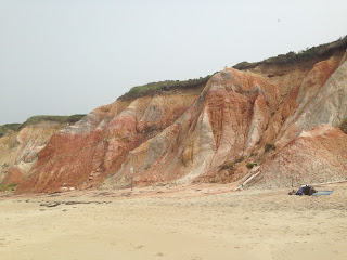
The clay cliffs, such as the ones found in Aquinnah were
created by the pressure or weight of the glacier. The clays were under the sea bed, but were
forced upward.
We squashed clay to mimic the upward thrust.

We squashed clay to mimic the upward thrust.


Resources
Oldale, R.N. (2001). Cape Cod, Martha’s Vineyard, and
Nantucket: The Geologic Story. Yarmouth Port, MA: On Cape Publications.
Cooper, Doug.
“Understanding the Island’s Geology in 3 Walks.” Presentation through
the Adult and Community Education of
Martha’s Vineyard, MA, 7-26, 2016.


